UPDATE: 2:30 p.m.
BC Wildfire Service and the Columbia Shuswap Regional District have shared the most recent updates to the Bush Creek East wildfire, including expected details pertaining to structure loss in the coming days.
In a 2 p.m. briefing, BCWS information officer Forrest Tower joined CSRD officials to talk fire size, expected growth and potential structure loss in communities under evacuation orders and alerts.
In response to a media question about structure loss, which noted the Thompson Nicola Regional District had released confirmation that 11 properties had been destroyed or damaged in its jurisdiction, CSRD protective services team leader and emergency operations director Derek Sutherland shared that work is active in Shuswap communities to assess damage and said those results may be made available as soon as this evening (Aug. 23) or tomorrow.
Once that information is confirmed, it will be sent directly to the property owners impacted, he said.
As for fire growth, Tower confirmed what had been shared by the CSRD earlier Wednesday. All evacuation alerts and orders remain in place until accurate estimates of fire growth can be made.
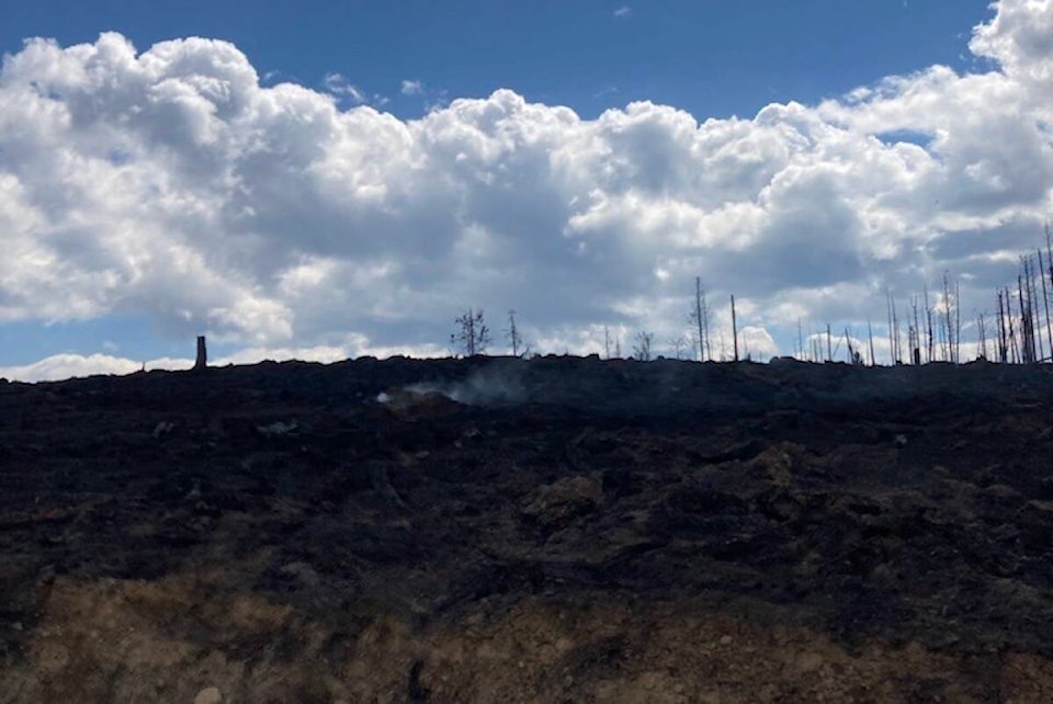
The CSRD’s report states additional rain occurred yesterday evening, and areas on the northwest section of the fire received upwards of 20 millimetres of rain, with varying amounts between 2-11 millimetres recorded elsewhere. Temperatures today were forecasted to reach 11 degrees with 47 per cent humidity. Rain and thunderstorms may develop later as well. Wind and rain have the potential to cause danger trees to fall and people in the area should exercise extreme caution, reads the CSRD update.
Danger tree assessment and tree falling are ongoing along the Anglemont/Squilax road to Scotch Creek starting at the Squilax Airstrip. Aircraft were able to fly yesterday afternoon when smoke cleared and an updated perimeter will be mapped when visibly allows flight over the entire fire and helicopters are not imminently required for other operations, said the CSRD.
Tower stressed that when a perimeter update comes, it could be large in regards to number of hectares of spread since visibility has been reduced for days due to smoke, but asked people to keep in mind it did not all occur in one day and likely isn’t a threatening number as the hectares are spread out across the sprawling perimeter.
“It does not mean it is moving in any particular direction,” said Tower. “It’s a reflection since Aug. 18, all the data currently being processed.”
He also said the BCWS doesn’t expect any major growth for the fire, but stressed there are areas still exhibiting active behaviour and weeks left of summer wildfire season.
A large contingent of wildland firefighters, nearing 150 members, is on its way to the blaze, said Tower, as part of a provincial system that sends resources to fires based on need. He said Bush Creek East is now ranked number one on B.C.’s emergency Resource Sharing Wildfire Allocation Protocol (RWSAP).
In the Little Shuswap area, 20 millimetres of rain was recorded at the Cahilty weather station. Crews are working from the top of the saddle into the Loakin Valley, east of Banshee Lake.
West and East of Adams Lake, BCWS is monitoring the properties on both sides of Adams Lake and working with the Ministry of Transportation and Infrastructure to get the Holding Bridge repaired and the Holding Road cleared. Ferry management is engaged with any repairs, maintenance, or fueling required. There is an effective community response engaged with BCWS on both sides of the lake. The Interfor strike team continues to mop up in the Adams FSR area. Interfor is also working with crews to extinguish hot spots above Agate Bay.
In Scotch Creek and Lee Creek, two unit crews are working on building a hand guard along the fire’s edge behind the communities. Heavy equipment is also working to build guards above the communities.
In Celista and Magna Bay, heavy equipment has completed a machine line upslope of structures in Magna Bay and is continuing towards Ross Creek.
In Turtle Valley and Sorrento, crews are anchoring off Turtle Valley, establishing hose lays upslope from English road. Heavy machinery is building an equipment guard off of English Road. Crews are working on a hand line around structures near Sorrento. Crews are also working to build a guard to the east of Sorrento, along with heavy equipment. Direct fire suppression was ongoing along Highway 1 yesterday (Aug. 22).
Structure Protection task forces are also working in Scotch Creek, Lee Creek, Turtle Valley and Sorrento.
The panel briefly touched upon local residents remaining on their properties amid evacuation orders. Tower stressed communication is key.
“[BCWS] wants people to leave in evacuation orders but if they have made the choice to stay on private property…if you want to do that you need to communicate with us. There are ways we can work together,” said Tower.
Sutherland added there is a system in the works with CSRD to allow for better collaboration between the regional district, BCWS and communities.
Original story:
As the Bush Creek East wildfire continues to burn, a new evacuation alert was put in place on Tuesday night.
On Aug. 22 at 8 p.m., Neskonlith Indian Band issued an evacuation alert for Switsemalph 3 near Salmon Arm. The alert has been put in effect because of heavy smoke in the area and not because of an active wildfire threat.
Due to the heavy smoke, BC Wildfire Services haven’t been able to update their mapping since Sunday, Aug. 20, meaning the blaze remains at 41,041 hectares.
On Tuesday, some areas of the blaze received up to two millimetres of rain. Crews continued to battle the blaze with direct attacks, receiving bucketing from helicopters. Heavy machinery is being used to help create containment lines and structure protection crews remain on scene.
According to the Columbia Shuswap Regional District (CSRD), more than 4,600 properties were on evacuation order and 864 were on alert. The evacuation map can be found on the CSRD website.
Transport Canada and the BC Wildfire Service prohibit the use of drones of any size near a wildfire. The operation of any aircraft not associated with fire suppression activities within a radius of five nautical miles around a fire, including unmanned aerial vehicles (UAVs or drones), is illegal. Anyone found interfering with wildfire control efforts may face penalties up to $100,000 and or up to one year in jail.
Black Press Media will keep updated throughout the day.
READ MORE: Premier Eby tours wildfire devastation in Central Okanagan
@cunninghamjordy
jordy.cunningham@kelownacapnews.com
Like us on Facebook and follow us on Twitter and subscribe to our daily and subscribe to our daily newsletter.